
Deskripsi
Download Brosur : Brosur GPS Geodetik Hi-Target V30+ Plus RTK GNSS
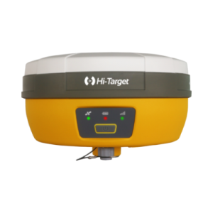
GPS Geodrtic Hi-Target V30+ (Plus) di desain dengan ramping, ringan serta kokoh yang dapat memudahkan penggunanya ketika membawa alat ini kemana – mana.
Alat ini memiliki fitur canggih yang dapat membantu anda melakukan pengukuran yang luas supaya pekerjaan lebih praktis dan mudah di kerjakan karena alat ini memiliki ketelitian yang sangat tinggi sehingga mampu menghasilkan pengukuran yang akurat.
GPS Geodetic Hi-Target V30 Plus GNSS RTK dirancang untuk memenuhi standar kualitas tinggi dengan harga yang terjangkau. Hal ini luar biasa di kelasnya, dengan desain compact kelas industri dan fungsi user-friendly. Untuk memudahkan perawatan dan operasi sederhana , sistem RTK GNSS V30+ Plus ini disediakan dengan desain modular. Jadi, jauh lebih mudah bagi pengguna untuk menginstal atau radio pertukaran UHF.
Beli juga : GPS Map Garmin 64SC
Indosurta Samarinda jual GPS Geodetic Hi-Target V30+ (Plus) dengan harga terjangkau dan bergaransi resmi 1 tahun. Untuk pembelian alat silahkan hubungi kami atau bisa juga datang ke toko alat survey kami.
Fitur GPS Geodetic Hi-Target V30+ GNSS RTK
- Multi Satellite Tracking Constellition
- Fitur Dari GPS Geodetik V30 Plus
- Multi-constellation tracking
- Intelligent operation
- Diversify RTK application
- Long Life Battery
- Rugged and unique design
Spesifikasi GPS Geodetic Hi-Target V30+ GNSS RTK
Satellite Signals Tracked Simultaneously
- Channels: 1408
- GPS: L1/L2/L5/L2C
- GLONASS: L1/L2/L3
- BDS: B1/B2/B3/B1C/B2a
- Galileo: E1/E5 AltBOC/E5a/E5b/E6
- SBAS: L1/L5
- QZSS: L1/L2/L5/L6
- NavIC (IRNSS): L5
- Global correction service: Hi-RTP (optional)
- Base and Rover: Interchangeable
Positioning Performance
- High Precision Static GNSS Surveying
- Horizontal: 2.5 mm + 0.1 ppm RMS
- Vertical: 3.5 mm + 0.4 ppm RMS
- High Precision Static GNSS Surveying
- Static and Fast Static
- Horizontal: 2.5mm + 0.5 ppm RMS
- Vertical: 5 mm + 0.5 ppm RMS
- Static and Fast Static
- Post Processing Kinematic (PPK / Stop & Go)
- Horizontal: 8mm+1ppm RMS
- Vertical: 15mm+1ppm RMS
- Initialization time: Typically 10 min for base and 5 min for rover
- Initialization reliability: Typically > 99.9%
- Post Processing Kinematic (PPK / Stop & Go)
- Code Differential GNSS Positioning
- Horizontal: 25cm+1ppm RMS
- Vertical: 50cm+1ppm RMS
- SBAS: 0.5 m(H), 0.85 m(V)
- Code Differential GNSS Positioning
- Network RTK
- Horizontal: 8mm+0.5ppm RMS
- Vertical: 15mm+0.5ppm RMS
- Initialization time: Typically 2-10s
- Initialization reliability: Typically > 99.9%
- Network RTK
- Real Time Kinematic (RTK)
- Horizontal: 8mm+0.5ppm RMS
- Vertical: 15mm+0.5ppm RMS
- Real Time Kinematic (RTK)
- Hi-Fix
- Horizontal: RTK + 10 mm/minute RMS
- Vertical: RTK + 20 mm/minute RMS
- Hi-Fix
Communication
- Bluetooth: 4.0/2.1 +EDR, 2.4GHz
- Network Communication:
- 4G cellular mobile network (TDD-LTE, FDD-LTE, WCDMA, EDGE, GPRS, GSM)
- Wifi frequency is 2.4G, support 802.11b/g/n protocol.
Internal UHF Radio
- Frequency: 403-473Mhz
- Channels: 116 (16 scalable)
- Transmitting power: 1W/2W/4W adjustable
- Support Multiple protocols:
- HI-TARGET
- TRIMTALK450S
- TRIMMARK III
- TRANSEOT
- SATEL-3AS,
- etc.
- Working Range: Typically 3~5km, optimal 5~8km
External UHF Radio
- Frequency: 410~470MHz
- Channel: 8
- Transmitting power: 5W/25W adjustable
- Support Multiple Protocols: TRIMTALK450S, TRIMMARK III, TRANSEOT
Power Supply
- Internal Battery
- 5000mAh lithium-ion rechargeable and removable battery.
- RTK Rover (UHF/Celullar) for 10 hours.
- Internal Battery
- External Power
- 6-28V DC External power input (5-pin port) with over-charge protection.
- Power Consumption: 4.2 W
- External Power
Physical
- Dimension (W x H): 164mm x 83.5mm
- Weight: ≤ 1.4kg (includes battery)
- Data storage: 8GB ROM internal storage
Control Panel
- Physical Button: 1
- LED Lamp: Satellite, Signal, Power
Environment
- Water/Dustproof: IP67
- Shock and Vibration: Dsurvive a 2m natural fall on to ground
- Humidity: 100%, condensing
- Operation Temperature: -45°C ~+ 75°C
- Storage Temperature: -55°C ~+ 85°C
I/O Interface
- 1 x Mini USB Port
- 1 x TNC antenna connector
- 1 x DC power input (5-pin)
- 1 x SIM card slot
Data Formats
- Output Rate: 1Hz-20Hz
- Static data format: GNS, Rinex
- Network model: VRS, supports NTRIP protocol
- CMR& RTCM: CMR, RTCM 2.x, RTCM 3.0, RTCM 3.2
- Navigation Outputs ASCII: NMEA-0183
Kelengkapan :
- 1 Unit Base Configuration
- 1 Unit Rover Configuration
- 1 Unit Controller
- 1 Unit Radio External
- 1 Unit Tripod Alumunium
- 1 Unit Pole Stick
Layanan purna jual
- Bergaransi servis dan kalibrasi 1 tahun
- Gratis training alat
- Gratis pengiriman dan COD khusus Samarinda dan juga sekitarnya.
Alasan mengapa memilih Indosurta?
- Lebih dari 10 tahun berpengalaman di dunia survey dan juga pemetaan
- Setiap pembelian alat di Indosurta akan mendapatkan gratis kalibrasi selama 1 tahun, dan gratis pelatihan alat
- Produk berkualitas dan juga bergaransi resmi
Tentu saja kami menerima pengiriman keluar Samarinda
Lalu kami juga tersebar luas di kota – kota seluruh Indonesia, Seperti :
- Balikpapan
- Makassar
- Batam
- Surabaya
- Palembang
- Medan
- Manado
- Cikarang
- Semarang
- Banjarmasin
- Kendari
- Samarinda
Hubungi kami
Telepon : 0813-4577-2736
WhatsApp : 0813-4577-2736
Alamat kami
Jl. P.M Noor Perumahan Pondok Surya Indah, Blok BF 4, No.5, Kelurahan Sempaja Selatan, Kec.Samarinda Utara, Kota Samarinda, Kalimantan Timur
>> Lihat di sini <<
Baca juga : Sistem Koordinat Geografi pada Teknologi GPS


