Download Brosur: GPS Geodetic / GNSS Hi-Target V700S SLAM RTK
Deskripsi
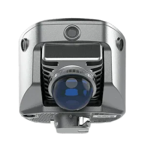
Hi-Target V700S merupakan perangkat canggih yang menggabungkan teknologi SLAM dan RTK, mampu memberikan hasil pengukuran dengan akurasi hingga tingkat sentimeter di berbagai kondisi medan — mulai dari area terbuka hingga lokasi menantang seperti lorong sempit, bawah jembatan, maupun di dalam ruangan.
Dengan fitur Laser Reverse Positioning, V700S tetap mampu bekerja presisi tanpa sinyal GNSS berkat sistem pemetaan visual dan pemrosesan laser secara real-time tanpa memerlukan titik kontrol. Kolaborasi antara RTK dan SLAM memungkinkan perangkat ini menghasilkan output BLH dan NEZ secara otomatis, sehingga surveyor dapat melakukan pemindaian tanpa perlu kalibrasi ulang.
Selain itu, V700S mendukung pengambilan koordinat dari jarak jauh cukup dengan mengambil foto target, menjadikannya aman digunakan di area berisiko tinggi. Untuk pekerjaan pemetaan tanah, perangkat ini mampu menghasilkan point cloud 3D yang padat dan detail, ditenagai oleh chip GNSS 1.408-channel serta fitur anti-jamming untuk menjaga kestabilan sinyal.
Hi-Target juga menyediakan perangkat lunak desktop khusus untuk pascaproses data, pembersihan hasil pemindaian, hingga analisis volume dengan cepat dan akurat.
Beli juga: Automatic Level Waterpass Bosch GOL 32D
Bagi Anda yang membutuhkan GPS Geodetic / GNSS Hi-Target V700S SLAM RTK, produk ini tersedia di Indosurta Samarinda dengan garansi resmi 1 tahun. Hubungi kami sekarang untuk informasi pembelian dan dapatkan penawaran harga terbaik.
Spesifikasi GPS Geodetic / GNSS Hi-Target V700S SLAM RTK
GNSS Configuration
- Channel: 1408
- GNSS Signal:
- GPS: L1C/A, L1C, L2P(Y), L2C, L5
- BDS: B1I, B2I, B3I, B1C, B2a, B2b
- GLONASS: L1, L2, L3
- GALILEO: E1, E5a, E5b, E6
- QZSS: L1, L2, L5, L6
- NavIC: L5
- SBAS: L1, L2, L5
- PPP: B2b-PPP, E6-HAS
- Output format: ASCII: NMEA-0183, Binary
- Output rate: 1Hz~20Hz
- Static data format: GNS, Rinex
- Real Time Kinematic: RTCM2.X, RTCM3.X
- Network Mode: VRS, FKP, MAC, Support NTRIP protocol
System Configuration
- Operation system: Linux
- Storage: Circulating 512GB ROM
Accuracy and Reliability
- High-Precision Static: H: 2.5 mm + 0.1 ppm RMS, V: 3.5 mm + 0.4 ppm RMS
- Static and Fast Static: H: 2.5 mm + 0.5ppm RMS, V: 5 mm + 0.5ppm RMS
- PPK: H: 8mm + 1ppm RMS, V: 15mm + 1ppm RMS
- PPP: H: 10cm, V: 20cm
- Code Differential GNSS Positioning: H: ±0.25m+1ppm RMS SBAS: 0.5m (H), 0.85m (V), V: ±0.5m+1ppm RMS
- Real Time Kinematic (RTK): H: 8mm+1ppm RMS Initialization time: Typically <10s, V: 15mm+1ppm RMS Initialization reliability: Typically > 99.9%
- Tilt Survey Performance: 8mm+0.3mm/°tilt
- AR Stakeout: Support
- Image measurement: A single photo can acquire multiple point coordinates, with an accuracy of better than 5cm within 15 meters
- Real-time accuracy evaluation: Supports
Camera
- Pixel: 3 Professional HD Cameras
- Function: Support AR stakeout, image measurement, working distance 2~15m
Laser Scanner
- Range: 0.1~ 40m@10%, 0.1~ 70m@80%
- Point Measurement Rate: 200,000 pts/sec
- Laser product classification: Class 1 Eye Safe
- FOV: H: 160°, V: 59°
IMU
- Update rate: 200Hz
Communication
- I/O Interface: USB type C port; SMA antenna port; Nano SIM card slot
- Network: TDD-LTE,FDD-LTE,GSM
- WiFi: IEEE 802.11a/b/g/n/ac/ax,2.4GHz/5GHz,Wifi hotspot
- Bluetooth: Bluetooth 5.2
- Internal UHF Radio:
- Power:0.5W/1W Adjustable Frequence: 410MHz~470MHz
- Protocol: HI-TARGET, TRIMTALK450S, TRIMMARK III, SATEL-3AS, TRANSEOT, etc.
- Channel: 116(16 scalable)
Sensor
- Electronic bubble: Supports
- Tilt Survey: Built-in High-precision IMU Module
Control Panel
- Physical button: Single button
- Display: 2.8 inch, 480×640 pixel touchable screen
- LED lights: Mode, Accuracy, Network
Application
- Advanced function: NFC, WebUI, Firmware upgrade via U-disk
- Intelligence application: Intelligent Voice, Self-check
- Remote service: Message push, online upgrade, remote control
Physical
- Power:
- Lithium battery, portable charger
- RTK rover(UHF/Cellular): up to 10 hours, SLAM mode: up to 5 hours
- USB 45W fast charging, fully charged in 2 hours
- Size: fully charged in 2 hours
- Weight: 68kg
- Power:
Environments
- Water/dustproof: IP64
- Humidity: 100% non-condensing
- Operation temperature: -20°C~+55°C
- Storage temperature: -40°C~+70°C
Kelengkapan
- 1x V700S GNSS Receiver
- 1x Battery
- 1x Qpad X9 Tablet
- 1x Radio Receiving Antenna
- 1x Survey Pole Hi-target(new logo)2.2m
- 1x Power Adapter
- 2x USB Data Cable 2
- 1x Tablet Bracket 1
- 1x Survey Benchmark
- 1x Rover Plastic Case
- 1x Certificate Of Quality
- 1x Warranty Card
- 1x Plastic Case PVC Label (Hi-Target)
- 1x Envelope
- 1x Hi-Survey software
- 1x Hi-LiDAR(Optional)
Keuntungan beli di Indosurta Samarinda
- Pengirimannya cepat dan Gratis ongkir di wilayah Samarinda dan sekitarnya
- Setiap alat sudah terjamin kualitasnya
- Garansi 1 tahun